 |
| The northern hardwood forest leaves got increasingly colorful as the trip progressed |
After a hiatus of many years, I’ve come to relish backpacking again in recent years, starting with a memorable trip mostly off-trail high in the Wind River Range in August 2017. I was introduced to backpacking as a 16-year-old by my parents when we took a family trip to the Tetons in August of 1974. I marvel that my parents, who were not experienced or avid outdoors people, were adventurous enough to take four kids ages 10, 16, 17 and 18 backpacking when they had never been backpacking themselves. I’m eternally grateful to them for that introduction, and for the equally influential introduction to canoeing in the Boundary Waters Canoe Area our family had three years before that.
That trip with my family in 1974 and another family backpacking experience on Lake Superior’s Isle Royale in 1976 set the stage for a handful of my own solo and two-person backpacking trips from my late teens through mid-20s. Trips of six to seven days in Canada’s Banff National Park, a return to Grand Teton National Park, Rocky Mountain National Park, and Glacier National Park were all wondrous mountain explorations for a lifelong Minnesota flatlander. However, there was a period of over 20 years between my last backpacking trip with my wife Anne in the mid-‘80s and my next trip, with Jakob when he was 15 in 2007. Jakob and I had a memorable outing on the Highline Trail and north to Upper Waterton Lake in Glacier National Park, but for a variety of reasons my wilderness experiences were otherwise limited to roughly annual canoe trips in the BWCA between that last backpacking trip in the mid-‘80s and my return to backpacking in 2017.
 |
| Indian Pass, Wind River Range, August 2017 |
The return to backpacking in the Wind River Range was a grand, rugged affair, much of it scrambling over
boulders, talus slopes, glaciers and snowfields between 10,000 and 12,150 feet for five days. The total solar eclipse of August 21, 2017, the first day of the trip, was a bonus mind-blowing experience. Off-trail travel appealed to my sense of adventure and desire for immersion in wild nature, and my next two backpacking trips were similarly rugged and even more remote in southern Utah’s Escalante Canyon and its side canyons. Those trips in March 2019 and March 2021 (with the September 2020 aborted SHT thru-hike in between) took me down the Escalante River from near its headwaters just downstream of the town of Escalante to just above the highest reaches of Lake Powell (which backs up from the Colorado River’s Glen Canyon Dam into the lower few miles of the Escalante Canyon). The Escalante hiking involved dozens of river crossings daily (sometimes in thigh- to crotch-deep, cold, fast water), along with crossing talus slopes, boulder fields, and bushwhacking through sometimes nearly impenetrable tamarisk thickets. Side explorations up Harris Wash, Neon Canyon, and Coyote Gulch took me through further redrock wonderlands (the Golden Cathedral! Jacob Hamblin Arch!). Smitten with the great American Southwest, I continued my backpacking explorations in March 2022 with trips to Big Bend and Grand Canyon National Parks.
boulders, talus slopes, glaciers and snowfields between 10,000 and 12,150 feet for five days. The total solar eclipse of August 21, 2017, the first day of the trip, was a bonus mind-blowing experience. Off-trail travel appealed to my sense of adventure and desire for immersion in wild nature, and my next two backpacking trips were similarly rugged and even more remote in southern Utah’s Escalante Canyon and its side canyons. Those trips in March 2019 and March 2021 (with the September 2020 aborted SHT thru-hike in between) took me down the Escalante River from near its headwaters just downstream of the town of Escalante to just above the highest reaches of Lake Powell (which backs up from the Colorado River’s Glen Canyon Dam into the lower few miles of the Escalante Canyon). The Escalante hiking involved dozens of river crossings daily (sometimes in thigh- to crotch-deep, cold, fast water), along with crossing talus slopes, boulder fields, and bushwhacking through sometimes nearly impenetrable tamarisk thickets. Side explorations up Harris Wash, Neon Canyon, and Coyote Gulch took me through further redrock wonderlands (the Golden Cathedral! Jacob Hamblin Arch!). Smitten with the great American Southwest, I continued my backpacking explorations in March 2022 with trips to Big Bend and Grand Canyon National Parks.
 |
| Rio Grande River from the Marufo Vega Trail, Big Bend National Park, March 2022 |
With these recent experiences under my belt, including three hard days of backpacking in the Grand Canyon (55 miles and 12,000 feet of climbing, almost all after breaking my ulna in a freak slip about two miles after starting), I was confident that I could enjoyably hike the SHT in something like 15 to 18 days. This would require averaging about 17 to 21 miles per day for the full 310 or so miles of the thru-hike, including spurs to overlooks, campsites, and food pickup. I decided to time my trip to coincide with leaf-change season in northeastern Minnesota. Hiking in late September through early October trip offers the bonus of a bug-free trip, a not inconsiderable thing given how intense mosquito and biting fly pressure can be during mid-summer in the Arrowhead.
 |
| The view to the north across the Pigeon River into Canada from the 270-Degree Overlook |
which affords stunningly beautiful views north to the Pigeon River and Canada beyond. Jakob and I had a nice chat with Randy Cadwell of ICTV (Itasca Community Television), who was filming for a planned segment of their Common Ground series, on the North Country Trail (which incorporates the SHT). After admiring the views for a few minutes, we were southbound, and the thru-hike was officially underway. Jakob accompanied me for another five miles or so before turning back, leaving me on my own for the rest of the thru-hike.
The first few miles were relatively easy, with only modest climbs and relatively good footing. It soon became apparent, though, that the relatively easy stretches were not the norm. Root- and rock-strewn trail was much more common, with steep ups and downs for every small creek and more major river crossing (of which there were many). The root-strewn stretches were often the most difficult as the footing was treacherous in the extreme. Balsam fir, white and black spruce, and white cedar roots frequently completely covered the trail for significant distances. I also had my first gorgeous vistas looking both inland and out to Lake Superior. These were always enjoyable and brightened up this and every subsequent day of hiking. The deciduous trees (primarily maples, aspens and birch) were still primarily green, which was surprising. I had expected to follow leaf-change south as I  progressed on the trail, but I had seen more color further south on the drive up than I did the first day on the trail.

Because of a late start (around 10:20 a.m. from the parking lot), I didn’t make as many miles as hoped on the first day, and pulled into the North Carlson Pond campsite at about 5:45 p.m. The SHT has a wonderful system of designated primitive campsites (94 in total), some quite close together but often with gaps of several to as much as nine or so miles between them. In this case, it was another four miles to my planned stop for the night, but I didn’t have the time or energy to make it that far. Dispersed camping is prohibited, and all of the campsites have multiple tent pads (typically room for between three and six tents), and the expectation is that the sites be shared by all comers. I ultimately split my nights on the SHT evenly between campsites I shared with other trail users and those I had to myself. It was a nice mix of trail camaraderie and solitude, both of which I appreciated.
 |
| SO MANY beautiful rivers and creeks... |
 |
| The 1.4-mile lake walk section north of Grand Marais, lovely but slow walking |
After that it was early to bed, as darkness fell shortly after 7:00 and it was getting cold rapidly. This was to be the drill for the rest of the trip – hike all day, get into camp shortly before dark, set up camp, have dinner, clean up, and hit the tent early. I simply didn’t have the energy or inclination to sit up late by a campfire, and most campsites had been picked over pretty well for dry firewood as well. This was alright by me, as it gave me a bit of time to write in my journal and read for a bit before falling asleep, exhausted.A few evenings I got into camp early enough that I was able to write and read outside before dark, sitting in my camp chair, a one-pound luxury item that I’ve greatly appreciated on recent trips. As I enter my mid-60s, I’m no longer interested in sitting on the ground or on a log in camp. Most SHT campsites had rough planks supported on logs to sit on, but I preferred using
these as a table instead while I sat in comfort in my Helinox Chair Zero camp chair.
these as a table instead while I sat in comfort in my Helinox Chair Zero camp chair.
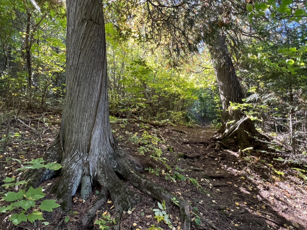 |
| Old-growth white cedars were relatively common; old-growth pines less so |
- Backpack – Zpacks Arc Blast 55L
- Quilt – Enlightened Equipment Enigma (950 down, 30-degree rating)
- Sleeping pad – Therm-a-Rest NeoAire XlLte
- Tent – REI Flash Air 1 with polcyro footprint
- Cook kit – Kojin alcohol stove with Toaks Sidewinder surround and Ti pot
- Water filtration and carrying – Sawyer Squeeze with 1 liter pouch and Cnoc Vecto 3L container
A final change I’ve made in recent years is to use trekking poles. I initially used them on my March 2019 sojourn in the Escalante Canyon, as I knew I’d be crossing the river many times daily and wanted the stability trekking poles provide. They were literally lifesavers on that trip, as a rain one night mid-trip meant thigh- to crotch-deep river crossings in fast water tor the last few days. I’ve been hooked on them since, and use my Black Diamond Distance Z poles go with me on every trip now. End digression…
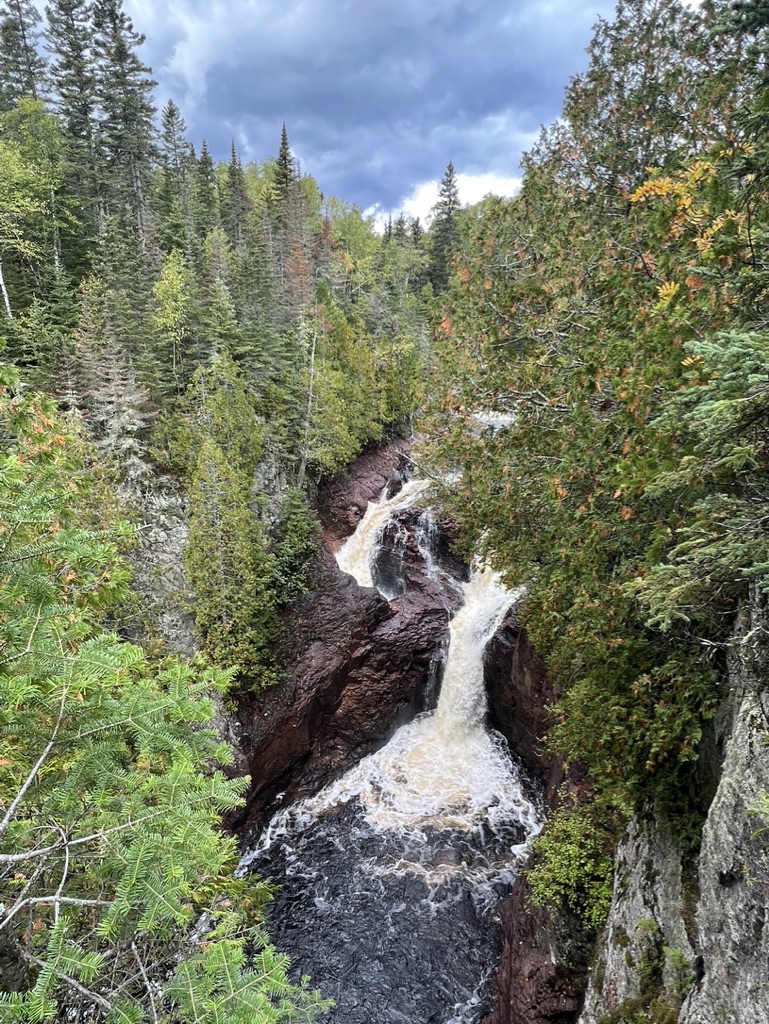 |
| Devil's Kettle, Brule River |
Over the next 11 days, I got into a rhythm of rising pre-dawn, having a quick breakfast of oatmeal and cocoa-laced coffee, hitting the trail between 7:30 and 8:00 a.m., asking myself out loud “What am I gonna do today?” and responding “I’m gonna walk all fucking day!!!” with a heartfelt smile. I truly got into the thru-hike spirit, and in spite of long, hard days, and eventually nights where everything from my knees down to my toes ached, I reveled in the feeling that I was doing exactly what I wanted to be doing all day every day, and that there was nowhere else I wanted to be. One of the beautiful things about backpacking is that you're traveling slowly enough to take everything in, get lost in your thoughts, and merge with your surroundings.
 |
| The fabled Bean and Bear Lakes overlook did not disappoint |
 |
| Beaver ponds were numerous and often beautiful |
 |
| Luna the shelter pup! |
 |
| Unlike the 4th Musketeers, this porcupine was a welcome trail companion |
groups of six to 12 (exclusively men) passed me, I asked a guy what the number 4 on his shirt represented, and he told me they were part of a men’s movement, the 4th Musketeer. Days later, when I had internet service, I found that this was one of their “Xtreme Character Challenges.” Kinda weird (and it would have been more than kinda creepy had I been a single woman). Where in the world were these 80 guys even going to camp?!? Strange experience.
 |
| Gorgeous campsite at Agnes Lake |
In spite of the challenging days, I continued to feel totally immersed in the experience and thoroughly enjoyed every day, but I was getting ready for a break in the action. From day eight through day 12 I logged between 21.3 and 24.3 daily miles on often rough trails. This put me in position to reach Duluth’s Canal Park the afternoon of day 13. The SHT enters the northeast edge of Duluth, travels on some beautiful trails through city parks, a nature center, and some UMD natural land, then drops down on city streets to the Lakewalk and Canal Park. I was well and truly fired up for Canal Park, as I had been  fantasizing about a meal and beer(s) at Canal Park Brewing Company (right on the trail!!!) for many days at this point. The triumphal entry and hike along Duluth’s Lakewalk were every bit as wonderful as I had anticipated, and the meal and beers at CPBC were satisfying beyond my wildest dreams. The experience was capped by a nice chat with a young waitress who was interested in someday thru-hiking the SHT.

A few more miles down the urban section of the trail I diverted to my sumptuous quarters at the Motel 6 and had one of the most divine showers of my life. Exceptionally fine pizza and beer with a jazz trio providing music followed at Ursa Minor Brewing, which I could just manage to stagger to a few blocks away. This all seemed surreally wonderful after 12 nights of sleeping in my cramped one-person tent and 13 days of hard, hard hiking. After about 10 hours of deep sleep, I awoke refreshed the next morning, stopped at the Duluth Grill next door for my third excellent meal in a row, purchased two king-sized Snickers bars to supplement my dwindling food supplies, and headed back onto the trail for the final two days of the trip.
Duluth’s city trails are exceptional. Both coming into and leaving the city, I hiked many miles of beautiful trails along creeks and the high ridge southwest of downtown. What I had thought would be a somewhat boring stretch through the city was instead a fascinating introduction to a portion of Duluth’s wonderful natural environment. A highlight was a stop at Enger Park, where the Ohara Peace Bell graces a lovely Japanese garden. I stopped to toll the bell and appreciate the built beauty momentarily before pushing on.
 |
| Ancient white pines near Jay Cooke State Park |
From around Split Rock State Park south I had seen very few people (other than in Duluth), including one day where the only person I saw was in the campsite I stopped at for the night, and the next day where the only person I saw was a Minnesota Department of Agriculture forester out doing field research on gypsy moth populations. That all changed as I hiked through Jay Cooke State Park on a bluebird sky Saturday, the 15th and final day of my hike. Throngs of people were out enjoying the beautiful fall colors. It was great fun to cross the historic swinging bridge over the St. Louis River, rubbing elbows with the day-hiking masses. I felt like a world beater, and in spite of significant trail fatigue, I hiked at a rapid pace all day after starting in the frigid, dark pre-dawn at the private Fond du Lac campground that was the only option for my last night.

I had phoned Anne a few times since the return of phone and internet service in the Duluth area, and we had arranged for a 4:30 p.m. pickup at the Wild Valley Road trailhead. The southern terminus is 1.9 miles past the trailhead parking lot, so when I hit the parking lot at around 2:55, I knew I had just over 90 minutes to hike the 3.8 miles to the southern terminus and back. This wouldn’t be at all challenging walking at a normal pace at home, where I can easily average about 18-minute miles with a full backpack on. However, on the still-rugged trail, I knew I would really have to scoot to keep Anne from waiting. I scurried along and hit the long-anticipated southern terminus at around 3:40. Jubilation! I checked the log book, and saw that my friend Kathy B, who had seen a post on Facebook when I hit Canal Park Brewing that I would likely be at the terminus on Saturday, had congratulated me in advance as she and her dog Zest had been there the day before! After making a brief entry in the log book, I flew back down the trail and made it back the parking lot and the waiting Anne (and faithful cairn terrier Ruby) at 4:25.

I have a renewed appreciation of the value of living life in the slow lane, with my home on my back. I know that this will remain a big part of my life as long as I am physically able to lace on my trail runners, put a pack on my back, and make my way slowly through the wondrous landscapes that remain on this beautiful planet. Let us praise backpacking!